
Rivers are a dominant and enduring feature of Irish towns and cities, natural elements that have consistently served and interacted with urban development. They are firmly embedded within the topographies of towns, confidently defining the shape of the network of streets and buildings that grow and change around them. The name or names of a town often relate to water. Belfast (modern Irish Béal Feirste) is ‘mouth of the sandbank’, or more expressively ‘approach to the tidal ford’ across the River Lagan, and Dublin (Dubhlinn) is simply ‘black pool’, a feature of the lowest reaches of the River Poddle. Bandon (Droichead na Bandan) is the name of the local river, possibly derived ultimately from a pagan goddess.
Major rivers were strategically important for the earliest Viking and Anglo-Norman town-builders and continue to act as focal points for urban life to the present day such as the River Shannon in Athlone and Limerick, Nore in Kilkenny, Boyne in Trim and Liffey in Dublin. Similarly the characteristic Rivers Foyle and Bandon would have played important roles in the development of the planned, plantation towns of Bandon and Derry in the seventeenth-century. In contrast, local rivers are at a remove in Armagh, Kells and Kildare, all examples of towns that evolved out of early Christian monasteries.
Places divided by a river often have a dual story. Counties were divided by rivers at Athlone, Belfast and Bray. The distinctive ‘Hightown’ and ‘Irishtown’ of medieval Kilkenny and Limerick were separated by their secondary channels, the River Breagagh and Abbey River respectively. Bridges, of course, act as the connectors and respond to the topography of their associated river as opposed to the importance or size of the urban centre — fourteen bridges were recorded prior to 1900 in the small town of Maynooth but only two in Derry.
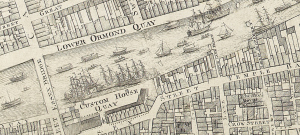
River Liffey, Dublin, by John Rocque, revised by Bernard Scalé in 1773. © Royal Irish Academy. To be reproduced in IHTA, no. 26, Dublin, part III, 1756 to 1847 by Rob Goodbody (forthcoming 2014).
| 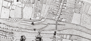
2. River Nore, Kilkenny, by John Rocque, in 1758. © Trinity College Dublin. Reproduced in IHTA, no. 10, Kilkenny, by John Bradley (2000). Extract orientated east–west.
|
Early large-scale town plans give us some insight into what life may have been like along the rivers. In Dublin, John Rocque’s map of 1756 (revised by Bernard Scalé in 1773) illustrates the city’s quays with ships populating the Liffey as far inland as the then custom house (present-day site of the Clarence Hotel, Wellington Quay) and focus clearly on the river (1). In Kilkenny, however, Rocque showed the houses and plots of the High Street backing onto the water on his map of that city in 1758 — more characteristically of an Irish country town, it is the significant mill and associated sites further north on the river that appear to dominate (2). Sometimes a watermill was located right in the middle of town, as at Longford and Sligo; more usually one or more mills were positioned towards the edge or even completely outside, as at Fethard, Trim and Tuam. An extract from the large-scale Ordnance Survey town plan of Longford from 1836 shows the River Camlin and the appropriately named Great Water Street (3). A distillery (1824) was succeeded by a corn mill, then a flour mill and eventually a saw mill (1911), each in turn harnessing the power of the Camlin River and utilising the storehouses and yards of this complex for its own purposes. Breweries and other manufactories, such as weavers in Dublin, often choose river sites, and early hospitals exploited the resource such as St Francis Abbey in Kilkenny
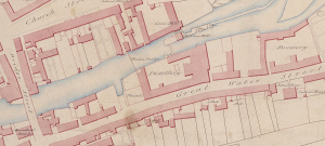
3. River Camlin, Longford, Ordnance Survey, 1836. © National Archives of Ireland. Reproduced in IHTA, no. 22, Longford, by Sarah Gearty, Martin Morris and Fergus O’Ferrall (2010).
|
The towns and topics discussed above are taken from the Irish Historic Towns Atlas (IHTA) series. The IHTA is a research project based in the Royal Irish Academy, Dublin. Twenty-three Irish towns and cities have been published to date (seehttp://www.ria.ie/research/ihta/publications.aspx for full list). Each atlas contains large format maps and views of different dates that allow one to compare towns with one another. There are accompanying gazetteers that give detailed histories of streets and sites. A user’s guide has been published, which is especially aimed at teachers: Reading the maps: a guide to the Irish Historic Towns Atlas, by Jacinta Prunty and H.B. Clarke (2011) and the recently published Maps and texts: exploring the Irish Historic Towns Atlas provides further comparative studies. Special prices are available from the Royal Irish Academy for teaching sets of the above publications (contact [email protected]). The ‘Digital Atlas of Derry’ is available at http://www.ria.ie/digitalatlasderry.aspx. More information on the project at http://www.ihta.ie.